
Satellites for Climate Intelligence [Innovation]
Climate Research innovation presents an opportunity to shift from the era of “Reactive Observation” to a “Proactive Planetary Management” model.

A satellite-based climate research system is a specialized suite of multi-spectral sensors and onboard AI engineered to ensure that planetary shifts (upon detection) are translated into actionable atmospheric models.
Climate Research innovation presents an opportunity to shift from the era of “Reactive Observation” to a “Proactive Planetary Management” model, where the mitigation of global warming is as precisely engineered as the satellites that track it.
I. Where is Climate Research Innovation most needed?
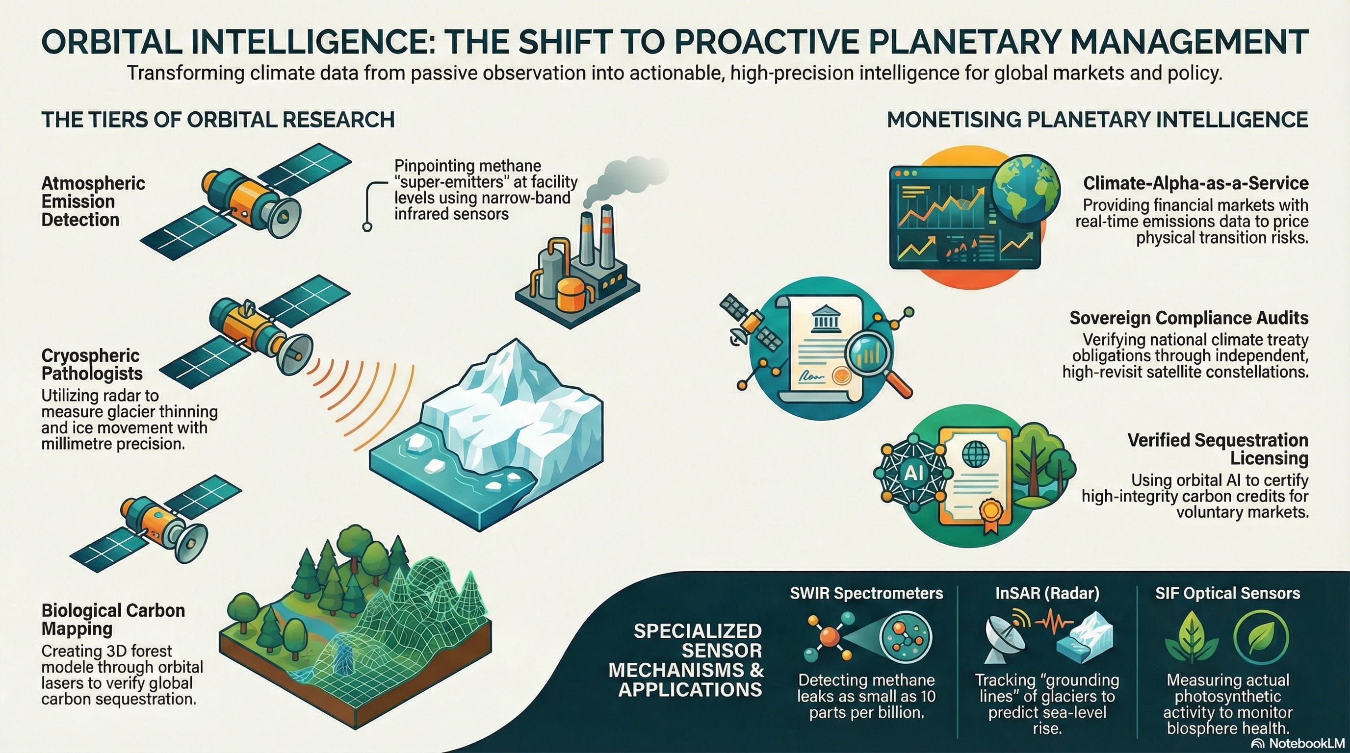
The demand for advanced orbital systems is driven by the growth of “tipping point” risks, the need to protect the global carbon budget from unaccounted leaks, and the mandate for “High-Resolution Accountability” (HRA).
1. The Atmospheric Level (Greenhouse Gas Point-Source Detection)
This tier focuses on preventing the “invisible” accumulation of warming agents by identifying specific emitters and natural feedback loops.
Methane-Specific Spectrometry: Utilizing narrow-band infrared sensors to pinpoint “super-emitter” events (such as pipeline leaks or landfill off-gassing) down to a single facility level.
Aerosol-Cloud Interactions: Deploying polarimetric sensors to measure how human-made particulates alter cloud reflectivity (albedo), a critical variable in the Earth’s energy imbalance.
Vertical Profile Sounding: Engineering limb-sounding instruments that “slice” the atmosphere to measure gas concentrations at specific altitudes, preventing the averaging of data that hides localized warming pockets.
2. The Structural Level (Cryospheric & Oceanic Integrity)
At this level, researchers act as “Planetary Pathologists.” The value lies in ensuring that no subtle shift in the Earth’s ice or water goes undetected before it reaches a point of no return.
Interferometric Radar (InSAR): Utilizing phase-shift technology to measure glacier thinning and ice-shelf movement with millimeter precision, providing early warnings for sea-level rise.
Spaceborne Bathymetry: Replacing traditional sonar with blue-green lasers (Lidar) that penetrate coastal waters to map coral bleaching and seagrass carbon sequestration in 3D.
Gravimetric Mass Tracking: Deploying twin-satellite “chase” configurations (like GRACE-FO) to measure minute changes in Earth’s gravity, which reveal the movement of deep-aquifer groundwater and melting polar mass.
3. The Biological Level (Forest & Soil Carbon Sequestration)
This tier focuses on the shift toward “Nature-Based Solutions.” The goal is to utilize remote sensing to verify the integrity of global carbon sinks.
Biomass Lidar Mapping: Using orbital lasers to “look through” forest canopies, creating 3D models of tree trunks and branches to accurately calculate the total carbon stored in global jungles.
Soil Moisture Microwave Sensing: Integrating L-band microwave radiometers that can “see” through vegetation and several centimeters into the soil to track drought progression and desertification.
Fluorescence Imaging: Detecting the faint “glow” emitted by plants during photosynthesis (Solar-Induced Fluorescence) to measure the actual productivity of crops and forests in real-time.
4. The Regulatory Level (Verification & Climate Compliance)
This tier provides the data and assurance needed to meet increasingly strict international climate treaties and carbon-trading standards.
Sovereign Emission Verification: Embedding high-revisit constellations into international law to verify that nations are meeting their “Nationally Determined Contributions” (NDCs) under the Paris Agreement.
Predictable Climate Modeling: Utilizing high-fidelity “Digital Twin” software to prove to policymakers the effectiveness of specific geoengineering or reforestation projects before they are funded.
Supply-Chain Traceability: Integrating automated deforestation alerts that trigger trade-compliance audits when “protected” biomes are breached by industrial or agricultural expansion.
II. Types of Climate Sensors & Applications
Unlike traditional weather sensors designed for broad atmospheric trends, Climate Intelligence Sensors are engineered for “Hyper-Spectral Precision.” Each sensor type utilizes a specific portion of the electromagnetic spectrum to detect “fingerprint” signatures of planetary change.
1. Short-Wave Infrared (SWIR) Methane Spectrometers
These sensors detect the specific absorption lines of methane by measuring the sunlight reflected from the Earth’s surface through the atmosphere.
Mechanism: Every gas has a unique spectral “fingerprint.” SWIR sensors focus where methane absorption is most distinct. By comparing the light intensity at these wavelengths, the sensor can calculate the exact concentration of gas between the satellite and the ground.
Research Example: MethaneSAT (Environmental Defense Fund), which uses high-resolution spectrometers to identify methane leaks as small as 10 parts per billion, providing a global map of oil and gas facility emissions.
Application: Super-Emitter Detection. Ideal for monitoring global energy infrastructure, allowing regulators to pinpoint “leaky” pipelines or malfunctioning flares that would otherwise go unnoticed by ground crews.
2. Multi-Angle Polarimetric Imagers (MAPs)
These instruments do not just look down; they view the same patch of Earth from multiple angles, measuring how light is polarized by particles in the air.
Mechanism: By analyzing the orientation of light waves (polarization) as they bounce off aerosols and clouds, these sensors can distinguish between different types of particulates (such as smoke, desert dust, or industrial sulfate )and determine their size and shape.
Research Example: NASA’s PACE mission (Plankton, Aerosol, Cloud, ocean Ecosystem), which uses the SPEXone polarimeter to quantify the cooling and warming effects of different aerosol types on the global climate.
Application: Cloud-Aerosol Forcing. Critical for narrowing the uncertainty in climate models regarding “albedo” (reflectivity), helping scientists understand how much human pollution is masking or accelerating global warming.
3. Spaceborne Interferometric Synthetic Aperture Radar (InSAR)
InSAR uses radar pulses to create high-resolution maps of Earth’s surface deformation by measuring the phase difference between two or more radar images.
Mechanism: Because radar penetrates clouds and darkness, it provides 24/7 monitoring. By bouncing microwaves off the ground and measuring the time it takes to return, the sensor can detect changes in surface elevation with millimeter-scale accuracy.
Research Example: NISAR (NASA-ISRO SAR), a joint mission designed to observe the world’s most complex processes, including ecosystem disturbances and the “flow” of ice sheets in Antarctica.
Application: Cryospheric Monitoring. Essential for tracking the “grounding line” of glaciers (the point where ice leaves the land and starts to float) which is the primary indicator of imminent sea-level rise.
4. Solar-Induced Fluorescence (SIF) Sensors
These ultra-sensitive optical sensors detect the very faint “glow” emitted by plants during the process of photosynthesis.
Mechanism: When plants absorb sunlight, a tiny fraction (about 1%-2%) is re-emitted as low-energy red and far-red light. SIF sensors isolate this “biological signal” from reflected sunlight, providing a direct measurement of actual photosynthetic activity rather than just “greenness.”
Research Example: ESA’s FLEX (Fluorescence Explorer), which maps the health of the Earth’s vegetation to monitor the “breathing” of the biosphere and its ability to sequester carbon.
Application: Precision Carbon Accounting. Used to verify the health of reforestation projects and to detect early-stage agricultural drought before physical wilting or browning occurs.
III. Example Business Models
These models focus on commercializing “Planetary Intelligence,” turning the necessity of climate monitoring into a high-margin, data-driven service for the global green economy and the financial sector.
1. The “Climate-Alpha-as-a-Service” (CAaaS) Model
Primary Tier: The Atmospheric Level (Greenhouse Gas Detection) and Regulatory Level.
Model: Operating as a specialized intelligence provider for the financial sector. Hedge funds and commodity traders pay the CAaaS provider for “Information Alpha”; real-time satellite data on methane leaks or crop yields that haven’t been factored into market prices. The provider manages a “Global Emissions Ledger,” offering a more accurate picture of a company’s carbon liability than their own sustainability reports.
Innovator Opportunity: Asset-Level Transition Risk. Developing a “Climate-Risk Score” for physical assets. By monitoring a factory’s thermal footprint and surrounding flood risks via satellite, this model allows insurers to price “Transition Risk” with granular accuracy.
SWOT Analysis:
Strengths: High demand from ESG-driven institutional investors; bypasses the “greenwashing” of self-reported corporate data.
Weaknesses: Highly sensitive to “data noise” and cloud cover; requires expensive high-revisit constellations.
Opportunities: Expanding into “Carbon Arbitrage” markets where traders bet on the delta between reported and satellite-verified emissions.
Threats: Open-source government data (like Copernicus/ESA) improving in resolution, reducing the “moat” of private data.
2. The “Verified-Sequestration-Licensing” (VSL) Model
Primary Tier: The Biological Level (Forest & Soil Carbon) and Industrial Level.
Model: Instead of selling raw images, this model focuses on the IP of “Algorithmic Verification.” The company licenses patented AI models that translate Lidar and Hyperspectral data into “Certified Carbon Tonnes.” Revenue is generated through “Verification Royalties” for every carbon credit issued on a voluntary market that uses their “Orbital Truth” DNA.
Innovator Opportunity: Digital-Twin Reforestation. Developing “Dynamic Growth Models” that use satellite data to predict exactly how much carbon a specific plot of land will sequester over 30 years, allowing for the pre-selling of high-integrity credits.
SWOT Analysis:
Strengths: Scalable software-centric model; essential for the credibility of the $2B+ Voluntary Carbon Market.
Weaknesses: Complex biological variables make 100% accuracy difficult; vulnerable to “model drift” as climate zones shift.
Opportunities: Partnering with drone-reforesting firms to provide “Precision Planting Maps” based on orbital soil-moisture analysis.
Threats: Ground-based IoT sensor networks becoming cheap enough to compete with orbital biomass estimation.
3. The “Sovereign-Compliance-Subscription” (SCS) Model
Primary Tier: The Regulatory Level (Verification & Compliance) and Logistical Level.
Model: A “Treaty-as-a-Service” subscription for national governments. The SCS provider manages a dedicated constellation for a country, providing the data needed to prove compliance with the Paris Agreement or to implement “Carbon Border Adjustment Mechanisms” (CBAM). Governments pay a “Verification Fee” to maintain their standing in international climate diplomacy.
Innovator Opportunity: Automated Border Carbon Taxes. Developing “Customs-Integrated Sensors” that automatically calculate the carbon intensity of an incoming cargo ship’s plume, allowing for real-time taxation at the port of entry.
SWOT Analysis:
Strengths: Long-term, stable government contracts; creates a “Single Source of Truth” for international disputes.
Weaknesses: Subject to geopolitical tensions and data-sharing restrictions; high barrier to entry due to security clearances.
Opportunities: Providing “Climate Forensics” to international courts for climate-related litigation against major polluters.
Threats: Geopolitical rivals launching “Counter-Satellites” to spoof or jam climate monitoring signals.
4. The “Bio-Reactive-Insurance-Audit” (BIA) Model
Primary Tier: The Structural Level (Cryospheric & Oceanic Integrity).
Model: Acting as the “Adjuster” for the insurance industry. The BIA provider operates a network of InSAR (Radar) and microwave sensors that track the “Infrastructure Stress Signature” of melting permafrost or rising sea levels. They sell forensic “Hazard Maps” to reinsurers to identify which coastal or arctic properties are becoming uninsurable.
Innovator Opportunity: Parametric Trigger Tagging. Selling “Smart-Contract Triggers” that, when a satellite detects a specific “Sea-Surface Temperature” or “Ice-Shelf Breakage” threshold, automatically trigger insurance payouts to affected communities without the need for manual claims.
SWOT Analysis:
Strengths: Critical for the survival of the global insurance industry; data is verifiable and difficult to dispute.
Weaknesses: High CAPEX for specialized radar satellites; requires complex integration into legacy actuarial systems.
Opportunities: Becoming the “Global Risk Benchmark” for municipal bonds and coastal real estate development.
Threats: Public-private partnerships (like NASA’s NISAR) providing similar high-res radar data for free.
IV. Enabling Technologies
Climate Research systems rely on High-Fidelity Planetary Modeling and Onboard Edge Intelligence. These technologies allow satellites to translate raw electromagnetic signals into precise environmental metrics while ensuring that data latency is minimized for rapid-response climate action.
1. Digital Twin Earth (DTE) Simulators
Converting petabytes of satellite data into a coherent climate prediction requires a virtual replica of the planet that can simulate “what-if” scenarios in real-time.
The Innovation: Digital Twin frameworks, such as the EU’s Destination Earth (DestinE), integrate real-time satellite feeds with high-performance computing to create a highly accurate digital mirror of the Earth’s systems (atmosphere, ocean, and ice).
Predictive Intelligence: These simulators allow researchers to input satellite-detected anomalies (such as a sudden surge in Arctic methane) to predict how it will impact global temperature gradients over the next decade. It transforms satellites from simple cameras into the “sensory organs” of a global predictive brain.
2. Space-Grade Edge AI Processors
To solve the “Data Bottleneck,” satellites are increasingly processing information in orbit rather than sending every raw pixel back to Earth.
The Innovation: Radiation-hardened Neural Processing Units (NPUs) and FPGAs (Field-Programmable Gate Arrays) allow satellites to run complex machine-learning models in the vacuum of space.
Intelligent Filtering: This enables “Edge-based Event Detection.” For example, a satellite can autonomously identify a wildfire or an illegal logging operation and downlink a high-priority alert and coordinates via a low-bandwidth link, bypassing the hours-long delay of full-image processing on the ground.
3. Laser Inter-Satellite Links (LISL)
Climate events are often interconnected across the globe; LISLs allow different specialized satellites to “talk” to one another at the speed of light.
The Innovation: Utilizing Optical Communication Terminals instead of traditional Radio Frequency (RF), satellites can transfer data at speeds exceeding 10 Gbps across thousands of kilometers of vacuum.
Cooperative Sensing: If a gravimetric satellite detects a massive ice-shelf fracture, it can instantly “cue” a high-resolution optical satellite in a different orbit to point its cameras at the event. This creates a “Connected Constellation” that provides a multi-perspective view of a single climate event as it happens.
4. Quantum Gravity Gradiometers
Measuring the invisible movement of water and ice requires sensing the minute changes in Earth’s gravitational pull.
The Innovation: Utilizing Cold Atom Interferometry (CAI), quantum sensors measure the interference patterns of atoms cooled to near absolute zero. These atoms are extremely sensitive to the local gravity field.
Mass Displacement Tracking: Unlike optical sensors, quantum gradiometers can “see” underground. They track the depletion of deep-crustal aquifers or the loss of “invisible” mass from the underside of glaciers. This technology provides the most accurate data possible for global water-security models and sea-level rise projections.
V. Example Innovators
The Climate Research ecosystem is composed of aerospace engineers, data scientists, and climate-tech firms dedicated to establishing a “Planetary Health Monitor.”
1. The Sensor & Platform Segment (The “Foundation”)
GHGSat (Canada): The global leader in high-resolution methane monitoring; their “Iris” and “Hugo” satellites provide facility-level emissions data for the oil, gas, and waste management industries.
Pixxel (India/USA): Pioneers in hyperspectral imaging; their “Firefly” constellation captures hundreds of spectral bands to detect subtle changes in soil health, crop stress, and mineralogy.
Planet Labs (USA): Operates the largest fleet of Earth-imaging satellites, providing a daily “scan” of the entire planet to track deforestation and land-use change in near real-time.
ICEYE (Finland): Specialists in SAR (Synthetic Aperture Radar) technology; they provide 24/7 monitoring of flood events, sea-ice changes, and volcanic activity regardless of cloud cover.
Capella Space (USA): Leading the push for high-resolution American SAR data, enabling sub-meter monitoring of infrastructure and environmental shifts.
Wyvern (Canada): Utilizing “unfolding” telescope technology to deliver high-quality hyperspectral data at a significantly lower cost for the agriculture and mining sectors.
MethaneSAT LLC (USA): A subsidiary of the Environmental Defense Fund, launching a mission to provide the most precise global data on methane leaks to drive international policy.
Carbon Mapper (USA): A non-profit/private partnership deploying satellites specifically designed to identify “point-source” and methane emitters at an unprecedented scale.
Muon Space (USA): Developing a software-defined “Climate Constellation” that can be rapidly reconfigured to track different environmental variables as climate needs shift.
AxelSpace (Japan): Providing the “AxelGlobe” platform which democratizes access to daily microsatellite imagery for regional climate monitoring.
2. The Analytics & Intelligence Segment (The “Gatekeepers”)
Pachama (USA): Utilizing AI and satellite imagery to verify the carbon sequestration of forest projects, ensuring high integrity in the voluntary carbon market.
Kayrros (France): A leading data analytics firm that integrates satellite data with proprietary algorithms to track global energy flows and environmental footprints.
Dendra Systems (UK): Combining satellite intelligence with drone-based “seeding” to manage large-scale ecosystem restoration and reforestation.
Orbital Insight (USA): Specializing in geospatial “Big Data” to analyze human activity patterns and their resulting environmental impacts on a global scale.
Descartes Labs (USA): Providing a cloud-based platform for processing planetary-scale data to monitor food security and supply-chain sustainability.
Climate Engine (USA): Translating complex satellite datasets into actionable insights for water resource management and drought monitoring.
Sust-Global (USA): Using satellite-derived data to help financial institutions assess the physical climate risk of their global asset portfolios.
Blue Sky Analytics (India): Developing “Climate Intelligence” APIs that monitor air quality, wildfires, and water risk in real-time.
Geophy (Netherlands): Integrating satellite data into real-time valuations for “Green Real Estate,” factoring in flood and climate risks.
SkyWatch (Canada): Acting as the “Amazon for Satellite Data,” simplifying how researchers and developers access and purchase climate-relevant imagery.
3. The Enabling & Regulatory Segment (The “Auditors”)
Loft Orbital (USA/France): Providing “Space-as-a-Service” by hosting climate sensors for multiple clients on a single satellite bus, reducing the cost of mission deployment.
Space4Climate (UK): A public-private partnership that ensures satellite data meets the stringent quality standards required for international climate reports and IPCC models.
AgriTIERRA (UK/Colombia): Utilizing Earth Observation to monitor sustainable supply chains and bioeconomy growth in the Global South.
Asterisk Labs (UK): A research cooperative developing unexpected applications for satellite data to solve localized climate challenges in the agrifood sector.
VI. Potential Opportunities for New Innovators
To transition from “Reactive Observation” to a self-sustaining “Planetary Management” economy, innovators are attempting to solve the challenges of data trust, real-time edge processing, and hyper-local climate attribution. This creates a high-value frontier for startups to build the essential “Climate Infrastructure” for the green economies of the 2030s.
1. “Data-to-Trust” Blockchain Verification
As climate litigation increases and carbon markets scale, the world needs third-party verification that satellite-derived climate data hasn’t been “greenwashed” or manipulated.
The Opportunity: Developing “Immutable Climate Ledger” services. By anchoring raw satellite sensor data to a decentralized blockchain at the point of downlink, an innovator can provide a tamper-proof audit trail for corporate emissions or carbon credit offsets.
Innovation Focus:
Satellite-to-Chain Oracles: Creating hardware-security modules (HSMs) for satellites that digitally sign environmental data before it ever leaves the spacecraft.
Automated Smart-Contract Payouts: Providing “Parametric Insurance” platforms that automatically trigger disaster relief funds the moment a satellite verifies a specific wind speed or flood level.
Example Innovators: CarbonSpace (Blockchain-backed carbon monitoring), Veritree (Digital restoration tracking).
2. Autonomous “Edge-to-Action” (E2A) Software
Raw data is a liability; actionable intelligence is the asset. Future missions will require modules that convert spectral signatures into immediate commands for ground infrastructure.
The Opportunity: Building plug-and-play E2A “Inference Engines.” These are low-SWaP (Size, Weight, and Power) AI modules that live on the satellite and are trained to recognize “Climate Anomalies” (like a new methane plume or a lightning strike in a dry forest) and alert local responders in seconds.
Innovation Focus:
Federated Learning for Satellites: Engineering AI models that “learn” from multiple satellites in a constellation without needing to send massive datasets back to Earth for training.
Zero-Latency Fire Alerts: Creating “Thermal Trigger” software that can distinguish between a controlled industrial burn and the early ignition of a wildfire, alerting fire departments via low-latency IoT links.
Example Innovators: Orbital Insight (Geospatial AI), Muon Space (Software-defined climate satellites).
3. High-Resolution “Digital Twin” Integration
Global models are often too “coarse” for city-level planning. The opportunity lies in bridging the gap between orbital “Macro-data” and local “Micro-decisions.”
The Opportunity: Translating planetary variables into “City-Scale Climate Sims.” This model sells high-resolution “Predictive Overlays” to urban planners, showing how a proposed park or building will impact the local “Urban Heat Island” effect or flood drainage.
Innovation Focus:
Ligneous/Urban Albedo Mapping: Using hyperspectral data to recommend specific sustainable materials for city infrastructure that will maximize cooling.
Hyper-Local Air Quality APIs: Developing “Street-Level” pollution models by fusing satellite atmospheric data with ground-based IoT sensor networks and traffic patterns.
Example Innovators: Descartes Labs (Data fusion), Blue Sky Analytics (Environmental APIs).
4. “Climate-Liability” & Sovereign Audit Services
The transition from voluntary climate action to “Mandatory Compliance” creates a new market for independent forensic auditing.
The Opportunity: Establishing the “Global Stocktake Clearinghouse.” This business model uses high-fidelity satellite data to provide “Sovereign Audit” reports, helping countries verify their neighbors’ climate treaty compliance or defending themselves against “Carbon Leakage” accusations.
Innovation Focus:
Real-Time CBAM Telemetry: Developing “Carbon-Border” trackers that calculate the carbon footprint of imported goods (like steel or cement) based on the observed energy intensity of the producing factory.
ESG Forensic Auditing: Helping institutional investors identify “Stranded Assets” by predicting which coastal properties or agricultural lands will be rendered unviable by climate shifts over the next 20 years.
Example Innovators: Kayrros (Energy/Emissions tracking), Sust-Global (Physical climate risk).