Subsurface Resource Mapping [Innovation]
As we exhaust easily accessible surface minerals on Earth and prepare for In-Situ Resource Utilization (ISRU) on the Moon, prospecting is being strengthened by emerging technologies.

As we exhaust easily accessible surface minerals on Earth and prepare for In-Situ Resource Utilization (ISRU) on the Moon, prospecting is being strengthened by emerging Subsurface Resource Mapping (SRM) technologies.
I. Strategic Market Drivers & Solvable Problems
The value of SRM potentially lies in its ability to de-risk high-stakes environments where traditional “trial-and-error” exploration is no longer economically or environmentally viable.
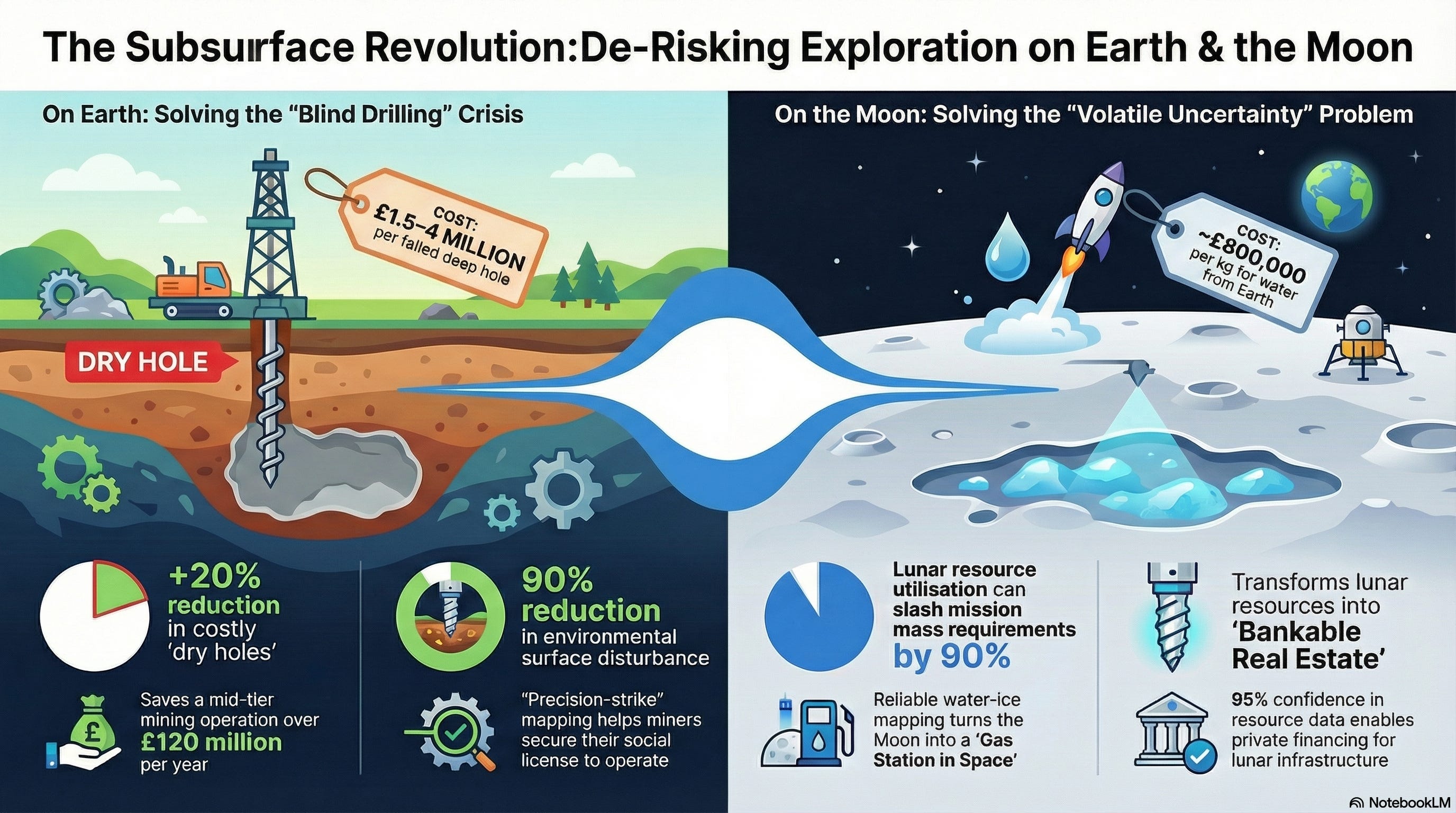
A. Terrestrial: Solving the “Blind Drilling” Crisis
The Exhaustion of Outcropping Deposits
Context: Most “Tier-One” deposits (those visible at the surface) have been discovered and mined. Future supply must come from deposits buried under 500m to 1,000m of “cover” rock or sediment.
SRM Solution: Advanced technologies like Borehole Muon Tomography and Quantum Gravimetry act as a “Subsurface X-Ray,” allowing miners to see through overburden that renders traditional sensors blind.
The “Dry Hole” Capital Sink
Context: The industry currently faces a $180B–$270B investment shortfall. A single failed deep-exploration drill hole can cost upwards of $2M–$5M.
SRM Solution: High-resolution imaging acts as a CAPEX Multiplier. By reducing the “dry hole” rate by just 20% through precise targeting, SRM could save a mid-tier mining operation over $150M per year in sunk exploration costs.
Environmental “Footprint” and Social License
Context: Massive “grid drilling” patterns required to find deep deposits cause significant environmental degradation and face intense regulatory pushback.
SRM Solution: “Precision-Strike” exploration. Using Ambient Noise Tomography (ANT) to identify targets remotely could allow for a 90% reduction in surface disturbance, securing the “Social License to Operate” in ESG-sensitive jurisdictions.
B. Lunar: Solving the “Volatile Uncertainty” Problem
On the Moon, water-ice is the foundational resource for the cislunar economy. However, the lack of subsurface data creates prohibitive mission risks.
The “Gravity Tax” and Mass Penalty
Context: Lifting water from Earth’s deep gravity well costs roughly $1M per kg. Failure to utilize local lunar ice forces Mars-bound missions to carry massive propellant loads from Earth.
SRM Solution: In-Situ Resource Utilization (ISRU). Reliable mapping could reduce Earth-to-Orbit (ETO) mass requirements by up to 90%, transforming the Moon into a “Gas Station in Space.”
Engineering the “Blind” Drill
Context: There is a critical data gap regarding the stratigraphy of volatiles. Knowing if ice exists at 20cm (harvestable with a light scoop) vs. 2m (requiring a multi-kilowatt, thermally shielded drill) is the difference between mission success and total hardware failure.
SRM Solution: Mapping the Permanently Shadowed Regions (PSRs) with Ground Penetrating Radar (GPR) and Passive Seismic sensors could allow for “Right-Sized” engineering, potentially saving billions in avoided launch mass and redundant hardware.
Economic Bankability of “Inferred” Resources
Context: Private equity cannot fund lunar infrastructure based on “scientific guesses.”
SRM Solution: Transitioning lunar assets from “speculative” to “Bankable Real Estate.” 95%+ confidence in subsurface resource density could allow for the issuance of debt and the creation of a lunar commodity exchange.
II. Technical & Commercial Limitations
A. Technical Constraints
The Depth-Resolution Paradox: There is currently a fundamental physics trade-off between how deep a sensor can see and the resolution of the image.
GPR provides centimeter-scale detail but is typically limited to the top 10–20 meters.
Muon Tomography can “see” 1km deep but requires exposure times of weeks or months to build a high-fidelity image.
Signal Attenuation & Conductive “Shielding”: On Earth, highly conductive materials (like wet clays) absorb radar waves, rendering GPR potentially useless. On the Moon, the “Antenna-Rover Coupling” problem remains: metal rover bodies often create “ringing” artifacts in radar data that can be mistaken for real subsurface layers.
Environmental Noise & Sensitivity: Quantum sensors (like Cold-Atom Gravimeters) are hypersensitive to “vibrational noise.” In an active mining environment or on a vibrating rover, the signal-to-noise ratio often collapses. Innovators are moving toward MEMS-based vibration compensation to allow these sensors to operate without massive, power-hungry isolation platforms.
B. Commercial & Regulatory Challenges
High CAPEX vs. Uncertain ROI: SRM hardware is expensive, and the data it produces is “probabilistic,” not certain. For mid-tier miners, spending $5M on an advanced mapping campaign that might still result in a “dry hole” is a difficult sell compared to traditional, albeit inefficient, drilling.
Data Siloing & Interoperability: Subsurface data is often trapped in proprietary formats. A lack of standardized “Digital Twins” means a Muon map from one company cannot easily be layered with a Seismic map from another, hindering the “Multi-Modal Fusion” necessary for greater accuracy.
III. Emerging Technical Stack
1. The Multi-Platform Acquisition Layer (Hardware)
Orbital/Aerial Reconnaissance:
Quantum Gravimetry: Measuring absolute gravity anomalies using cold-atom interferometers (e.g., Exail/Muquans) to identify massive ore bodies or lunar lava tubes from low orbit (LLOs).
Innovators: Exail (FR) (Industry-grade laser systems for cold-atom sensors), Delta g (UK) (Gravity gradient sensors for detecting hidden voids).
Polarimetric SAR (PolSAR): Utilizing L-band and S-band radar (e.g., ICEYE) to penetrate dry regolith or dense vegetation, revealing structural faults and subsurface moisture.
Innovators: ICEYE (FI) (Operating a commercial constellation of SAR satellites), Maxar/Vantor (USA) (High-res orbital imagery).
Terrestrial/Rover-Mounted Sensors:
Passive Seismic (ANT): Using Ambient Noise Tomography (e.g., Fleet Space ExoSphere) to map the “seismic hum” of a site. These are being miniaturized into “seismic carpets” for lunar deployment.
Innovators: Fleet Space Technologies (AU) (ExoSphere platform delivering 3D models in 48 hours), STRYDE (UK) (Ultra-lightweight seismic nodes).
Muon Tomography: Utilizing cosmic-ray muons to create “X-ray” density maps of structures up to 1km deep. New portable detectors (e.g., mDetect) allow for borehole insertion to map density from the inside out.
Innovators: Ideon Technologies (CA) (Borehole muon detectors for deep mining), Geoptic/mDetect (UK) (Miniaturized 60mm detectors for NQ-sized boreholes).
Quantum Magnetometers: “Diamond-on-chip” sensors (e.g., DeteQt) that detect ultra-fine magnetic field variations to map conductivity without ground contact.
Innovators: Deteqt (AU) (Developing scalable diamond-on-silicon sensors for GPS-denied navigation and mining), Cerca Magnetics (UK) (Optically pumped magnetometers).
2. The Edge-Processing & Connectivity Layer (Computing)
Satellite-IoT Backhaul: In remote mines or on the Moon, data cannot wait for physical retrieval. Low-latency satellite links (e.g., Fleet Space Centauri) transmit raw geophysical signals directly to cloud environments in real-time.
Innovators: Fleet Space Centauri (AU) (Nanosatellite constellation purpose-built for mineral geophysics data), SpaceX/Starlink (USA) (High-bandwidth backhaul for remote sites).
Edge-AI Triage: Onboard processing (using RISC-V or specialized AI chips) filters “noise” from quantum sensors, such as rover motor vibrations or thermal drifts, before transmission, reducing data bandwidth requirements by up to 80%.
Innovators: BrainChip (AU) (Neuromorphic AI chips for low-power edge sensing), Xilinx/AMD (USA) (FPGA-based signal processing at the sensor level).
3. The Data Fusion & Modeling Layer (Software)
Joint Inversion Frameworks: Instead of viewing a “Seismic Map” and a “Gravity Map” separately, AI models (e.g., Fleet Space / Stanford Mineral-X) perform a Joint Inversion. This mathematically forces multiple datasets (Density, Conductivity, Velocity) to agree on a single 3D geological model.
Innovators: Stanford Mineral-X (USA) (Pioneering “Intelligent Prospector” agents for sequential decision making), Fleet Space / HiSeis (Integrating hard-rock seismic with ANT).
Automated Domaining (AI GeoSeg 2.0): AI algorithms that automatically categorize rock types and mineral zones from fused data, reducing the “human-in-the-loop” interpretation time from weeks to hours.
Innovators: Geosoft/Seequent (NZ) (Leapfrog Geo for 3D implicit modeling), Datarock (AU) (AI-driven core image and geophysics analysis).
Standardized Interoperability: Adoption of formats like the Volume Data Store (VDS) and OSDU (Open Subsurface Data Universe) enables cross-platform collaboration between Muon, Seismic, and GPR providers.
Innovators: OSDU Forum (Standardized subsurface data platform), Bluware (USA) (VDS format for ultra-fast seismic data handling).
4. The Decision Intelligence Layer (Commercial)
Digital Twin Visualisation: Real-time 3D environments (e.g., ArcGIS Reality Studio) that allow geologists to “walk through” the subsurface in VR, identifying the most efficient drill paths.
Innovators: Esri ArcGIS Reality Studio (USA) (2025 updates include Gaussian Splatting for high-fidelity 3D reality mapping), Bentley Systems (USA) (iTwin for infrastructure/mining).
Probabilistic Risk Assessment: Moving beyond “Yes/No” targets to a heat map of Drill Confidence Levels, allowing miners to quantify the financial risk of every proposed $1M borehole.
Innovators: KoBold Metals (USA) (AI-driven mineral exploration using uncertainty quantification), Ikon Science (UK) (RokDoc for quantitative interpretation).
IV. Opportunities for New Innovators
The “Intelligence Stack” is far from complete, leaving critical gaps for startups and deep-tech entrants.
1. The “Subsurface Auditor” Role
Opportunity for independent verification.
Innovation Need: Standardized “Confidence Certificates” for subsurface data.
Opportunity: Startups that don’t own sensors but act as independent data auditors, using AI to verify the “truthfulness” of 3D models from multiple vendors. This is the “Moody’s or S&P” of the mining world.
2. Specialized “Lunar-Grade” Micro-Sensors
Lunar environments are hostile to standard Earth electronics (extreme cold, radiation, abrasive dust).
Innovation Need: Rad-hardened Micro-ANT nodes.
Opportunity: Innovators who can miniaturize Ambient Noise Tomography (ANT) into “deploy-and-forget” nodes the size of a hockey puck that can survive the 14-day lunar night and communicate via ultra-low-power mesh networks.
3. “Cross-Silo” Interoperability Software
Data siloing remains a key bottleneck for the “Intelligence Layer.”
Innovation Need: Universal Geological Data Translators.
Opportunity: Developing a software-as-a-service (SaaS) platform that can ingest raw data from a GPR rover, a Muon borehole sensor, and an orbital SAR satellite, and output a single, OSDU-compliant 3D model in real-time.
4. Strike-Avoidance as a Service (Urban Context)
Urban subsurface congestion is at an all-time high.
Innovation Need: Real-time “Look-Ahead” for Tunnel Boring Machines (TBM).
Opportunity: Integrating Quantum Gravity sensors directly into the cutting heads of TBMs or excavators. This provides a “dashboard” for operators to see 5 meters ahead of the blade, preventing the catastrophic utility strikes that currently cost billions in national GDP.
V. Economic Scenarios & Market Impact
Scenario 1: The “Proven Reserve” Inflection Point (Lunar)
The Breakthrough: SRM precision for volatiles (water-ice) and metals reaches a 95%+ confidence interval through multi-modal sensor fusion (Muon + Quantum Gravity + ANT).
Economic Impact: Lunar prospecting shifts from “scientific discovery” to “Investment-Grade Auditing.”
Bankable Real Estate: Lunar land “claims” (coordinated via the Artemis Accords or private registries) transition from speculative assets into bankable collateral. Private equity firms and institutional debt providers begin financing lunar infrastructure (landing pads, power grids) because the resource feedstock is “proven.”
The Cislunar Commodity Exchange: A secondary market for “In-Ground Water Futures” emerges. Companies like Lunar Outpost can trade “proven ice tonnes” before a single gram is extracted, providing the liquidity needed for $500M+ extraction missions.
Geopolitical Trigger: High-fidelity mapping reveals “Peaks of Eternal Light” with adjacent “Rich Volatile Pockets.” This triggers a diplomatic race to establish “Safety Zones” under the Artemis Accords, effectively creating the first extraterrestrial sovereign wealth zones.
Scenario 2: Green-Mining (Terrestrial)
The Breakthrough: Terrestrial mining firms adopt “Precision-Strike” extraction, where Ideon-style Muon imaging and Fleet Space ANT allow for zero-waste exploration.
Economic Impact: The “social license to operate” becomes a hard financial metric.
ESG Premium Pricing: Minerals (Lithium, Copper) extracted from “Low-Impact” mines that reduced their surface footprint by 80% and avoided “blind” tailing dams receive a price premium on the LME (London Metal Exchange).
Carbon-Tax Immunity: Regulators in the EU and North America grant lower carbon-tax rates to miners who use high-fidelity mapping to eliminate the energy waste of 20+ “dry hole” drill attempts.
The Effect: Traditional “bulk” miners who rely on massive open pits face “Stranded Asset” risks. They are unable to compete with the lower CAPEX and higher ESG scores of the “Precision Miners,” leading to a rapid consolidation of the industry around SRM-tech leaders.
Scenario 3: The “Digital Crust” Utility (Infrastructure)
The Breakthrough: Urban SRM (led by innovators like Delta g and Exodigo) becomes a mandatory regulatory requirement for all civil engineering projects over $10M.
Economic Impact: The “Underground Digital Twin” becomes a public utility.
Strike-Risk Insurance: Insurance premiums for tunnel boring and foundation laying drop by 40% when a “Quantum-Certified” subsurface map is provided.
Avoided Loss Value: In the UK alone, the cost of accidental utility strikes (estimated at £2.4B/year in 2024) is slashed by £700M+, providing a direct boost to national GDP.
The “Shadow” Real Estate Market: Cities like Singapore or London begin leasing “proven subsurface volumes” for automated logistics tunnels and high-density thermal energy storage, creating a new layer of municipal revenue.
VI. Example Five-Year Roadmap (Technical & Commercial)
This roadmap tracks the shift from experimental hardware to potentially integrated, bankable subsurface intelligence.
Phase 1: The Integration Surge (2026)
Technical: First “Edge-AI” Field Trials. Sensors begin performing real-time noise filtration (removing rover motor vibrations) at the sensor head rather than in the cloud.
Commercial: “Joint-Inversion” Contracts. Major miners (Rio Tinto, BHP) move from “equipment hire” to “Target Generation” contracts, where innovators are paid based on the accuracy of the predicted mineral grade.
Phase 2: The Lunar Frontier (2027)
Technical: Deployment of “Seismic Carpets.” Multiple lunar missions (Artemis IV & private CLPS landers) deploy wireless ANT networks to map water-ice depth at the South Pole.
Commercial: Lunar “Proven Reserve” Financing. The first private institutional loans are issued for ISRU equipment, secured by “proven” water-ice data rather than just government grants.
Phase 3: The Urban Digital Twin (2028)
Technical: Quantum Gravity Miniaturization. Backpack-sized sensors become a standard for urban civil engineering, replacing slow, high-frequency GPR for deep utility mapping.
Commercial: Regulatory Mandates. Major cities (London, Singapore) require a “Subsurface Digital Certificate” for all new infrastructure projects over $50M to reduce strike-risk insurance premiums.
Phase 4: The 4D Monitoring Era (2029)
Technical: Dynamic Muon Tomography. Borehole Muon sensors move from static “pictures” to 4D time-lapse movies, allowing mine managers to watch ore-body depletion or CO2 sequestration migration in real-time.
Commercial: Dynamic Resource Trading. In-ground minerals are traded as live-monitored assets on digital commodity exchanges, with prices fluctuating based on the “verified depletion” visible via 4D SRM.
Phase 5: The Translucent Crust (2030)
Technical: Universal Model Alignment. AI models achieve “human-free” domaining, where rock types and mineral boundaries are categorized with 98% accuracy without a geologist in the loop.
Commercial: The Global Subsurface Utility. High-resolution mapping data is managed like a public utility. Access to “Deep-Earth Intelligence” is as ubiquitous and standardized as GPS is for the surface today.